By John P. Bluemle
The average person traveling through the Red River Valley is likely to be impressed by the flatness of the land. Just about everyone knows that this extremely flat and fertile area was once the floor of a huge lake glacial Lake Agassiz. The flat glacial lake plain formed when sediment was deposited in the cold, still water of the lake. The lake sediment consists mainly of layers of silt and clay, deposited when streams flowing into the lake delivered large amounts of sediment to the lake.
Most everyone knows too that Lake Agassiz left a legacy of rich agricultural land. What most people don't know is that some of the small, almost imperceptible changes in the landscape and vegetation from place to place are partly the result of a series of events that happened while the area was flooded beneath the waters of the lake and partly the result of complex, modern biologic and geologic conditions in the Red River Valley.
One of the ways farmers have tried to control erosion due to blowing topsoil has been to plant shelterbelts. But have you noticed as you travel through the farmland west of Grand Forks, or in the Mayville or Grafton vicinity, how the trees in these shelterbelts are often far from uniform in the heights they reach? A mile-long shelterbelt, growing along one side of a section on what looks like almost perfectly flat and uniform land, may consist of regularly alternating tall and short trees so that it takes on a highly irregular or " beaded " appearance. On the adjacent side of the same section, an adjoining shelterbelt may be perfectly uniform with tall, even-crested trees throughout. "Beaded" shelterbelts are found west of the Red River, in North Dakota and Manitoba, but they are not present in Minnesota east of the river. There is a geologic reason for all this, and I'll try to explain it. To begin, the "flat" lake plain we are so used to is not quite as flat as it looks. Over much of the central part of the Red River Valley, the otherwise flat surface is marked by long, almost imperceptible grooves, which are best seen from a small airplane flying at a low altitude. Some of the grooves are as much as six miles long. They may be 3 to 10 feet deep and as wide as 75 or 100 feet. With dimensions like that, it's no wonder they are hard to notice.
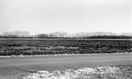
Beaded shelterbelt near the Grand Forks airport, west of Grand Forks along U.S. Highway 2. The trees grow to different heights - the line is "beaded" rather than of uniform height. (Photo by John Bluemle).
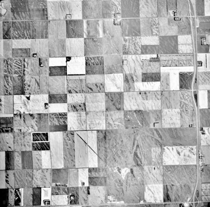
Aerial photograph showing lines on the floor of the glacial Lake Agassiz plain (see text). The lines are grooves that were gouged into the lake floor by icebergs dragging along the floor of the lake.
I've studied aerial photographs of the grooves on the Lake Agassiz plain in Walsh and Grand Forks counties. A large proportion of the grooves trend northwest. A possible explanation for this is that the icebergs (or lake ice) were propelled by winds blowing from the northwest or southeast. In the spring season, when the ice on Lake Agassiz would have been breaking up, the prevailing wind direction was probably from the southeast, as it is in the spring season today.
So, do the beaded shelterbelts occur everywhere that grooves are present in the lake floor? And do the trees simply appear shorter in the grooves because they just start out from a lower elevation there? No to both questions. Grooves that may have formed as a result of the wind-blown ice mechanism are present over a much larger area of the Red River Valley than are the beaded shelterbelts. But the beaded shelterbelts do have a definite relationship to the grooves. The taller trees in a beaded shelterbelt grow in the grooves; the shorter, stunted trees grow on the ridges or higher areas between the grooves. That's one of the reasons why it's so hard to detect the grooves; the lower areas are typically filled in with lusher vegetation than are the ridges between the grooves.
The second geologic factor that needs to be considered to understand the reason the shelterbelts are beaded is related to the eastward and upward movement of groundwater. This water has been seeping, under pressure, through layers of buried sandstone for millions of years and it is very salty in places. It comes to the ground surface in a fairly narrow strip of land parallel to and west of the Red River. The reason salty water is escaping to the surface in this particular area is that, farther west, the water-bearing sandstone is covered by a layer of shale that effectively seals it off so the water can't escape upward. The western edge of the area of upward seepage coincides with the eastern edge of the shale seal. The absence of the shale seal allows the salty water to escape in that area. The strip of salty land extends northward from the Wahpeton area to the north of Winnipeg. The salty area is restricted to the area west of the Red River and is not present east of the river in Minnesota.
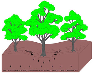
Taller trees grow in the grooves; stunted trees grow on the ridges between the grooves. Magnesium and sodium sulphate salts, which are left as residues from salty water rising from buried sandstone formations, build up, to higher concentrations in the ridges than in the adjacent depressions. This is because the salts are flushed downward from the lower areas by runoff water percolating downward, whereas the higher areas retain their higher salt concentrations. As a result, trees tend to grow better in the lower, more fertile, areas.
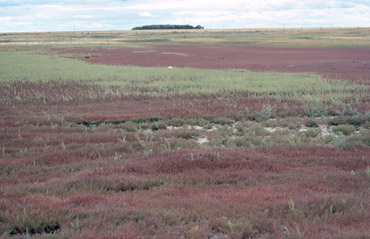 |
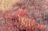 |
| Two photos of the reddish halophyte (salt-tolerant) plant, Salicornia rubra, west of Grand Forks. (Photos by John Bluemle). | |
Salt-water wells and salty sloughs, like Kelly Slough west of Grand Forks, are common over much of the area where salt seeps occur. Where the salty water reaches the surface, salt-loving plants such as Salicornia rubra, a small, red, salt-flavored plant, are common. In these areas, "white dirt" may be seen after a summer dry spell. This is salt-encrusted soil from which the salt water evaporated.
Beaded shelterbelts occur only in areas where the ice-gouged grooves coincide with places where the salty water is escaping to the surface. The interaction of these two factors grooves plus salty water is necessary for beaded shelterbelts to form.
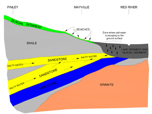
Generalized cross-section from west to east along the approximate location of State Highway 200. Saltwater escapes to the surface at the point where the shale cover is absent. Arrows represent the movement of salty water. The vertical scale of this diagram is greatly exaggerated.
So, what causes the beaded shelterbelts?
Even though salty water is escaping to the surface at about the same rate throughout the area, it becomes much more concentrated near the surface in slightly higher areas, such as on the ridges between the ice-gouged grooves. That's because runoff from precipitation fresh, salt-free water flows off the ridges, down to the lower areas. It infiltrates in the lower areas, flushing the salts from the soil and freshening it there. As a result, the soil in the grooves tends to be less salty and trees and other vegetation grow better there than on the intervening ridges where salty soil remains. The result is a "beaded" shelterbelt, with tall, healthy trees in the salt-free grooves, and stunted trees on the more salty ridges.
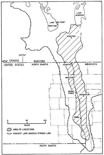
Area in the Red River Valley where ice-gouged grooves occur (lined area). The maximum extent of the glacial Lake Agassiz plain is shown by the tic-marked line.
