By John P. Bluemle
Glacial erratics are known all too well by most North Dakota farmers, who have laboriously piled them in the corners of their fields. Early settlers used the stones for the foundations of their homes and farm buildings, while other people built whole structures with them. Today, glacial erratics are sometimes used in landscaping, as rip rap along the faces of dams and shorelines, and on roads that are subjected to wave action (large numbers of them have been used to protect newly constructed roads from the rising waters of Devils Lake). Glacial erratics are even used as decorations in suburban front yards in towns like Bismarck and Minot.
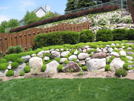
Landscaping in Bismarck, using glacial erratics and field stones. (Photo by Mark Gonzalez).
Locally, the rocks are usually referred to simply as field stones or boulders or just *!?/#! rocks, depending on one's point of view. Especially large rocks, too large to move out of the way, are sometimes called "leaverites" (as in "leave-er-right" there). Geologists though, know the rocks as glacial erratics, rocks that differ in lithology from the surface on which they are found. The term "erratic," with reference to rocks, apparently dates to 1779, when de Saussure, a Swiss geologist, described granite boulders lying on top of limestone in the Jura Mountains in Switzerland. His term, "terrain erratique," is derived from the Latin erratus, "to wander," and means, literally, "ground that has wandered." Geologists most commonly use the term erratic to refer to boulders and cobbles left behind by glacial ice.
Glaciers that moved over North Dakota left behind various kinds of erratics, rocks that would not otherwise be found in the state. Most were brought here from Canada. If you pick up a granitic rock in central North Dakota, you can be sure it had a Canadian source, although it isn't usually possible to determine just what part of Canada it came from. Sometimes though, the source of an erratic composed of limestone can be pinpointed. For example, in the area north of Winnipeg, several Paleozoic carbonate formations are quarried, and we can sometimes determine from which of these formations a North Dakota boulder was derived.
 |
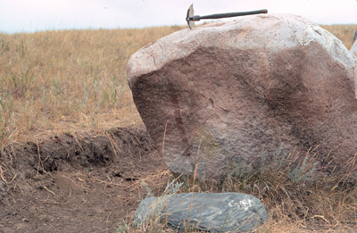 |
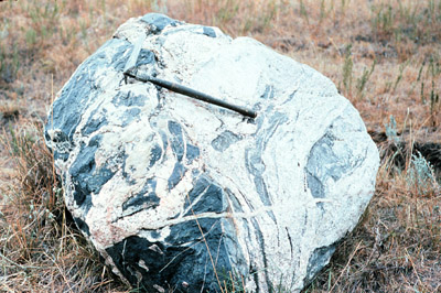
| Typical glacial erratic boulders. (Photos by Mark Gonzalez) | |
Only a few rock types are sufficiently distinct that the location of their source can be determined. Even so, some of them have been traced back to their source hundreds of miles away. Erratics have been used as exploration tools in the search for ore deposits.
Copper mines were opened in Finland after tracing copper-bearing erratics back to their source, and Quebec gold mines were founded after an analysis of gold-bearing erratics in Maine. Such tracking of erratics is one way that geologists can help to determine the history and source area of glacial deposits.
Several years ago, Bob Biek, a former North Dakota Geological Survey geologist, found some unusual erratics along Lake Sakakawea - dark-colored rocks known as "omars," (from the Omarolluk Formation, which outcrops today only in the Belcher Islands in southeastern Hudson Bay). Our Lake Sakakawea omars may have come from the Belcher Islands, or they may have come from an area where the Omarolluk Formation has since been eroded away. Omars are dark gray, fine-grained sandstone (graywacke), with characteristic calcareous concretions.
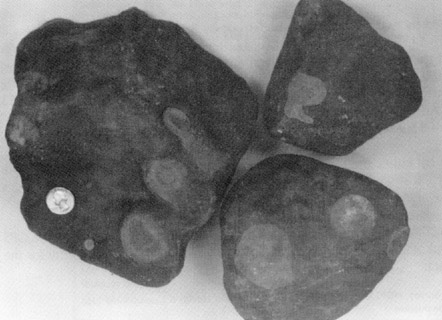
Typical “omars” with characteristic light-colored calcareous concretions. These erratics originated near Hudson Bay in Canada. They are found in North Dakota along the shore of Lake Sakakawea.
In contrast to the long-distance travelers, most boulders of sandstone were moved only a few miles by the glacier from nearby outcrop areas within the State. Sandstone is much less well consolidated than granite or limestone and any extensive glacial transport of sandstone boulders would normally break them down into much smaller fragments, or simply reduce them to sand. Occasionally, boulders of shale are included in layers of glacial sediment. Such boulders are fragile and have probably been moved only a few tens or hundreds of feet from their original source.
Most very large erratics, those three feet or more in diameter, tend to be igneous or metamorphic rocks, such as granite or gneiss. Such rocks are hard and much more resistant to abrasion and fracturing than sedimentary rocks such as limestone. In some places, uncommonly large granitic erratics (10 feet or more in diameter - some are car-sized, measuring up to 20 feet across) are numerous. A few examples include the walls of the Sheyenne River Valley near Fort Ransom; many of the high bluffs along the Missouri River; the valley walls along the Souris River near Velva; and along the White Earth River Valley in Mountrail County. West of Mandan, on 'Old Highway 10,' an exceptionally large erratic lies a few feet north of the highway - a true leaverite.
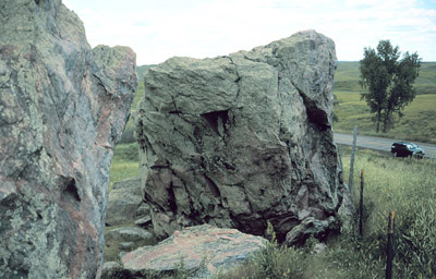
Large erratic west of Mandan along old Highway 10. This is the largest granitic erratic boulder I have seen in North Dakota.
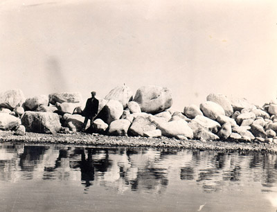
Man standing on the shore of Devils Lake in front of a pile of large erratics in 1910. This area is now submerged beneath several feet of water. (Photographer unknown).
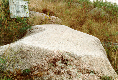
Most glacial erratics are rounded and worn, but some of them have beveled or faceted surfaces. During the course of their journey, the rocks were jostled against one another, or against the rock over which the glacier was flowing. As a result of this rubbing, the surfaces were planed smooth. Glacial transport fractured some boulders, producing fresh, angular edges. Some erratics are grooved or polished, a result of abrasion by the moving ice. Coarse sand and gravel within the ice scraped against the boulders, scratching or "striating" them, sometimes as the boulder moved along with the advancing glacial ice or when the glacier flowed over a hard, stationary rock. Striated boulders with straight grooves are sometimes found buried, in "boulder pavements," which are lag deposits of boulders that were covered by younger glacial deposits. If the boulders have not moved, the striations can sometimes be used to determine the direction of glacial flow.
 |
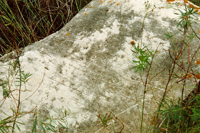 |
| Two glacial erratics, both located at the old Fort Ransom site. Both boulders, the upper one granitic and the lower one carbonate, have been planed off and striated (nearly straight lines have been scratched into the planar surface by the glacier.) (Photos by John Bluemle). | |
Glacial erratics aren't restricted to the surface where we can see them, but they occur throughout the entire thickness of glacial sediments, which averages between 150 and 250 feet thick throughout the northern and eastern parts of North Dakota. Seasonal freezing and thawing cause the rocks to work upward from below the plow zone to the land surface. Every farmer knows that each spring, a new crop of stones has to be removed from the fields. The smaller rocks can be picked up by hand or with rock-picking equipment and carried away. Larger erratics are sometimes blasted with dynamite and the pieces are hauled away.
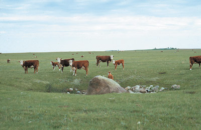
A “buffalo boulder” near Roseglen in McLean County North Dakota. Hereford cattle serve as proxy buffalo. (Photo by John Bluemle).
Some erratics are famous. Everyone has heard of Plymouth Rock where the Pilgrims first set foot in the New World on December 21, 1620. In North Dakota, we have the Standing Rock, near where Highway 46 crosses the Sheyenne River Valley. In 1839, the explorers Nicollet and Fremont noted the Standing Rock hill on their maps. Another large erratic, Writing Rock, near Alkabo in northwestern North Dakota, was known by the Sioux as Hoi-waukon or Spirit Rock.
In his book, Blue Highways, a backroads tour of rural America, William Least Heat Moon captured the resignation of farmers to a continual crop of boulders:
East of Fortuna, North Dakota, just eight miles south of Saskatchewan, the high moraine wheat fields took up the whole landscape. There was nothing else, except piles of stones like Viking burial mounds at the verges of tracts and big rock pickers running steely fingers through the glacial soil to glean stone that freezes had heaved to the surface; behind the machines, the fields looked vacuumed. At a filling station, a man who long had farmed the moraine said the great ice sheets had gone away only to get more rock. "They'll be back. They always come back. What's to stop them?"
 |
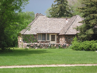 |
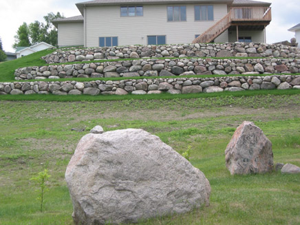
| Two photos of homes in Bismarck, both utilizing large numbers of glacial erratics and field stones. The slope below the home on the left has been terraced into three levels, with stones on the face of each terrace. Two large erratics are in the foreground. The picturesque home on the right, also in Bismarck, is constructed of field stones. (Photos by Mark Gonzalez). | |
